
| Town
Branch Neighborhood |
|
| News & Views Archives |
|
| Outdoor Recreation |
|
| Language Lane | |
| Louisiana
Tech University |
|
| University of Arkansas |
|
| Photo Albums | |
| Resource Links |
|
| About Us / Our Friends / Family |
|
|
September
10, 2003
|
||||||
| Residents
of mobile-home park evicted: Everyone in mobile-home park at 11th Street and South Duncan Ave. forced to move |
||||||
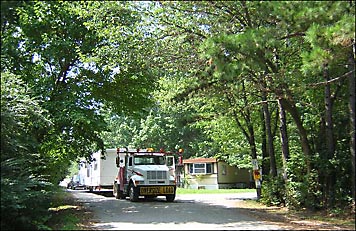
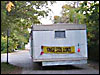
The mobile-home park north of 1101 South Duncan Ave. has been sold and everyone who lives there has been ordered to move away. The first mobile home was towed from the site Tuesday, Sept. 9, 2003. The woman who owns the home reported that she is moving to an established park on the periphery of Fayetteville. She will have a bit farther to drive to work each day, but her situation is not as bad as that of others displaced by the sale of the park. Some on Wednesday said they still have no idea where they will be moving. The buyer of the park reportedly has agreed to pay for moving the trailers, at lease up to a specified cost. Otherwise, many of the people would have no choice but to abandon their property. However, even those who find a space for their mobile homes expect to face an additional cost. Some have lived in the same place for many years and express the sense of loss that anyone who loses his home feels. Just because their houses are portable doesn't mean they want to leave the tree-shaded site where they have lived, in some cases, for decades. The mobile-home park on 11th Street covers several acres of savannah or partially timbered prairie. Until the 1930s, it was part of a dairy farm owned by the Wilson family. For some time after that, it was part of a traditional farm owned by the Dunn family. When a portion of the farm was subdivided, it became known as the Wilson-Dunn Addition.
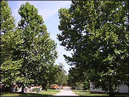
The mobile homes were situated on an almost flat area of moist-soil prairie where a wide variety of hardwood trees have grown tall and magnificent over the years. Because there is little pavement in the mobile-home park, rainwater soaks slowly into the ground as it always has and stands on the surface for a time after each rain. This water replenishes the shallow underground aquifer. There is seldom significant runoff from the site because of the soil type. The roots of the mature trees in the area prevent erosion and take up a lot of the moisture. Meanwhile, the majestic canopy formed by the branches shaded the mobile homes and kept utility bills relatively low. Ozark or Osage burrowing crayfish are plentiful in the area. These creatures do not live in the Town Branch with their more common cousins. They inhabit the aquifer and surface through chimneys formed from the mud they displace as they tunnel to the surface when the aquifer is full. People who live nearby, particularly those who live along the Town Branch of the West Fork of the White River, have expressed fear that a different sort of housing facility in the same area will increase the potential for flooding along the Town Branch. Plans for development of the site have not been made public. However, the buyer has been quoted as saying he has plans in the works to build numerous buildings in the area as well as upstream on the west side of Town Branch. Additionally, the same buyer has begun to take possession of parcels of land on the east side of Town Branch immediately to the west of South Hill Avenue. Apparently, many apartments, town houses or other multi-family dwellings will be constructed on the east side of the Town Branch. While the high ground along S. Hill is wetland prairie or savannah similar to that in the 11th Street mobile-home park, a significant area between the existing homes on S. Hill Ave. and the Town Branch between Sixth Street and 11th Street is wooded lowland wetland that historically has caught and slowed runoff from rain that frequently floods the Town Branch. Upstream to the north of Sixth Street, most of the land is developed. Fayetteville High School and the University own much of the headwater area of the Town Branch. Most of the water from the Cleveland Street and Razorback Road intersection and Cleveland and Garland intersection flows south and drains through the valley around Razorback Stadium, Walton Arena and the architect-designed Carlson Terrace married-student housing project. Water on the north side of Cleveland Street flows to the Illinois River watershed. As more and more of the land in the Town Branch watershed has been paved or roofed over, the flooding of Town Branch to the south has constantly increased. People who have lived along the west side of Ellis Avenue and the east side of Van Buren Ave. have seen high water in their back yards and the water has entered a house or two and threatened several. Two widely recognized historical events have been connected to the portion of Town Branch now slated for development. The Trail of Tears included camping sites in the area because of the many springs and natural ponds that provided travelers abundant and clean water. A sign near the south end of the UA soccer field commemorates a time when 1,100 Cherokees camped around the ponds that formerly were near what is now Sixth Street. The Butterfield Stagecoach Line used the route that is now South Hill Ave. and 11th Street and South Duncan Avenue to take travelers from Fayetteville to Van Buren by way of Hogeye. Several houses on South Hill Avenue and South Duncan Avenue are well over 100 years old and deserve protection for their historic status as much as any buildings in Northwest Arkansas. Some people in the neighborhood have lived in the same houses for 60 or 70 years. Many have lived in the neighborhood for more than 50 years. Members of the Town Branch Neighborhood Association have expressed concern not only about the flooding that could result from proposed development and the potential loss of trees and natural vegetation but also about the loss of historically significant sites that as yet have not been investigated and fully documented by archeologists or historians. No one knows how many burial sites may be in the area or how many prehistoric dwelling sites may be hidden by topsoil and vegetation in the Town Branch watershed. The hydrology of the area has never been studied to determine where the springs flow from or how big the underground caverns may be or what rare species may inhabit them. The aquifer is an unexplored underground maze that sustains not only the vegetation but also the wildlife and, as recently as the 1950s, provided all the water for many people who lived in the surrounding area. The small pieces of land that have never been developed were left alone because of their hydrological characteristics. With the relatively new Stormwater II federal regulations facing them, planners of the city of Fayetteville can be expected to look closely at all proposed changes in the area before issuing permits. Already, a 2-acre parcel of moist-soil prairie west of 1101 and 1121 S. Duncan and immediately to the south of the 11th Street mobile-home park has been approved for development as an apartment complex; and its developer has been issued a so-called nationwide dredge and fill permit by the U.S. Corps of Engineers. That parcel is of extremely rare quality because it has never been fully plowed and retains not only its water-absorbing soil but also a diverse stock of native plants displaying a constantly changing wildflower show throughout the growing season. The corps permit for the 2 acres requires that the water-retaining hydric soil and the seeds deposited there this fall be moved to the area slated for detaining water at the south end of the parcel. A sample of the flowering plants on that 2-acre parcel is documented in several photo albums on http://www.aubunique.com. Members of the Town Branch Neighborhood Association plan to meet with those planning to develop the historic area to learn specifics of their plans and a report will appear on aubunique.com soon. —Aubrey James Shepherd, Sept. 10, 2003 |
|
|||||

[Click here to email Aubrey]
Aubrey
James Shepherd
Fayetteville, AR © 2003, 2004, 2005
Site design by Lauren Hawkins' LDHdesign