
| Town
Branch Neighborhood |
|
| News & Views Archives |
|
| Outdoor Recreation |
|
| Language Lane | |
| Louisiana
Tech University |
|
| University of Arkansas |
|
| Photo Albums | |
| Resource Links |
|
| About Us / Our Friends / Family |
|
|
First printed in the |
||||
| Arkansas Audubon Plans Video of Eroding Banks of West Fork of White River | ||||
|
Jason Schultz WEST FORK — From about 1,000 feet up, erosion problems plaguing the muddy West Fork of the White River seem a lot clearer.
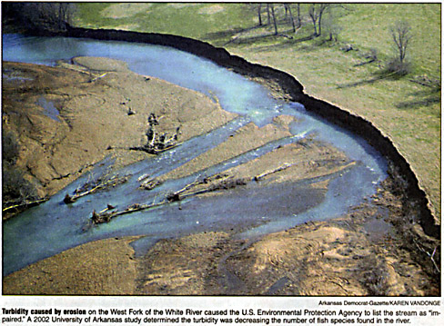
That was the conclusion of Audubon Arkansas education coordinator Fran Free on Friday after she piloted an aerial tour of the river in preparation for a video production the group plans. "I can totally picture the whole watershed better now," Free said. "From the air we can spot erosion problems we’re not able to get to from the ground." The Arkansas Soil and Water Conservation Commission hired Audubon Arkansas in 2003 to identify areas of erosion on the West Fork and recommend solutions. The U.S. Environmental Protection Agency listed the stream as being impaired in 1998 because of too much turbidity, or cloudy water. A 2002 study by the Arkansas Department of Environmental Quality determined that sediment from streambank erosion was one of the main contributors to the cloudiness of the river. A 2002 study by University of Arkansas at Fayetteville graduate student Andrea Radwell determined that the cloudy water was decreasing the number of fish species found in the river. Audubon Arkansas organized the flight to identify erosion areas it will later film for an educational video, Free said. Amy Wilson, director of public relations for the Beaver Water District, joined the flight because of the district’s interest in the river as a tributary to Beaver Lake. As she piloted a rented Cessna-172 single-engine plane over the meandering lime-green waters Friday morning, Free spotted an area of erosion the group had not identified before. Free spotted the erosion area downstream from a low water bridge on Dye Creek Road. She said that culverts under the bridge are spitting out water with so much force that it’s eroding a bank downstream, Free said. "It’s coming out of there like a fire hose," she said as the plane circled. Downstream from the bridge, the eroded sediment deposits, creating dirt and gravel bars that can be seen from overhead. Melissa Terry, conservation coordinator for Audubon Arkansas, said the group will take a look at possible solutions for the erosion near the bridge. One solution she suggested was redesigning the bridge to allow water to flow under the bridge with less pressure. Free began Friday’s tour by locating the headwaters of the West Fork near Winslow, then circling back and following the river north to Lake Sequoyah, where it merges with two other forks of the White River. In the headwaters area, the water was clear and the surrounding land had few isolated houses surrounded by densely wooded hilltops. That portion seemed to have the fewest erosion problems, Free said after the flight. "You can see the bedrock and it seems to be flowing the way it should," Free said. Heading north, the plane flew past Brentwood then over West Fork, where trees thinned and were replaced by green pastures and grazing cattle. There, the river turns a bright green due to algae, Free said. In places, sections of pasture land have eroded into the river creating a bank like a cliff. "That’s not a sustaining bank like that," Free said as she pointed to the steep banks. Between West Fork and Fayetteville, houses and businesses lined the stream and red clay showed developments under construction. Free slowed the plane and dropped lower to get a good look at the erosion, which she said is worst between West Fork and Fayetteville. Terry said the increasing development and decreasing tree cover contributes to the increasing erosion as the stream flows north. Vegetative "buffer zones" keep the bank from eroding, she said. Free pointed from the cockpit to a quarter-mile-long section of streambank in West Fork belonging to cattle farmer Mike McLeen. The 2002 Environmental Department study suggested that this streambank dumps about 6,600 tons of sediment into the river each year. That’s about 25 percent of the 26,550 tons of sediment the river dumps into Beaver Lake each year, according to the study. McLeen has been cooperating with Audubon Arkansas’ efforts to restore the stream bank along his property, Terry said. Audubon Arkansas is using a $125,000 grant from the Beaver Water District to design a plan to restore the bank. Another $123,000 EPA grant will pay for a watershed advisory group to create a restoration plan for the stream to be published in June. One of the plan’s recommendations is an increase in public education about the river, Terry said. Audubon Arkansas will hire a video company to shoot aerial footage of the West Fork based on the spots identified in Friday’s flight, Free said. That footage will be turned into an educational video which will be used in presentations about the river to civic groups and the watershed advisory group, Free said. |
||||
[Click here to email Aubrey]
Aubrey
James Shepherd
Fayetteville, AR © 2003, 2004, 2005
Site design by Lauren Hawkins' LDHdesign