
| Town
Branch Neighborhood |
|
| News & Views Archives |
|
| Outdoor Recreation |
|
| Language Lane | |
| Louisiana
Tech University |
|
| University of Arkansas |
|
| Photo Albums | |
| Resource Links |
|
| About Us / Our Friends / Family |
|
|
Updated
May 29, 2003
|
|||
| Development
Passes at May 27 Meeting: S. Duncan Ave. Apartments OK with Planning Commission |
|||
|
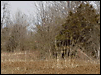
Developer James Mathias gained approval May 27 from the Fayetteville Planning Commission to build his South Duncan Ave. apartment complex. Since first considered by the Plat Review Committee in March, the scope of the project had been reduced from four buildings with 48 units to three buildings with 36 units. Members of the Town Branch Neighborhood Association worked hard and attended several public meetings in the effort that led to compromise on the size of the project. However, those who attended the May 27 meeting left unhappy that many of their expressed concerns were not addressed by the planning commission. Commissioners appeared to understand the validity of many of those concerns; however, the commission operates within a very limited scope, able to demand that developers follow city guidelines and ordinances but unable to adjust projects when the existing regulations do not actually fit the reality of a given development site. For instance, the fact that the project in question involves filling and paving over wetland did not stop the project. The rules require a plan to compensate for the lost protection from flooding that a natural wetland area provides. Building a pond to delay the release of stormwater from the project area fulfills the legal requirement as long as city engineers agree with the projections of the developer's engineer. The people whose property the runoff of the project will cross on the way to Town Branch do not believe that the proposed detention or retention pond will protect their homes in the event of a sustained heavy rain that would quickly fill the pond and allow it to overflow. Traffic problems, waterlines in the area that have broken frequently in recent years and cut off service in the neighborhood for many hours, the loss of nesting areas for songbirds in understory vegetation on the wetland prairie area, noise and air pollution during construction, the inability of several people who work nights and live near the project to sleep during construction, potential crime and noise created by the large increase in population in a mostly single-family neighborhood, the fact that more and larger development is planned upstream along the Town Branch and many other factors were not considered in the approval process. Neighbors calling for further study before approval were particularly unhappy. One neighbor was concerned that houses demolished on the front portion of the site were not inspected by proper experts when the refuse was removed and may have resulted in lead paint, asbestos and other potentially hazardous material being left near the surface. The commission did not discuss this problem. Similarly, a call for study of the shallow underground water courses on and adjacent to the property to be developed was not discussed by the commission, which had access to the minutes of a subdivision committee meeting at which this was emphasized because of concern over the potential reduction of underground water surrounding the site and thus a potential to cause adjacent land to develop sinkholes. Apparently, such concerns are not included in the commission's oversight responsibility. Unfortunately, appeal of projects that are approved by the commission is not automatic. People leaving the meeting expressed surprise and anger when told that a developer has an easier route to appeal if a project is denied than does an aggrieved neighborhood when a project is approved. This caused renewal of comments heard earlier from many people in the neighborhood that the developers have the money and the power and that there would be no point in attending meetings and speaking because their fear of the potential harm of the development would be ignored by public officials. It is up to the two council members from Fayetteville's Ward 1 to bring the neighbor's appeal before the council. Robert "Swifty" Reynolds and Brenda Thiel are the Ward 1 council members. Things may have appeared to be going slowly to some, but for neighborhood residents it has all happened quickly. On May 15, the Subdivision Committee of the Fayetteville Planning Commission sent the plan for the proposed South Duncan Ave. apartment complex to the full Planning Commission. On May 5, Mr. Mathias made a major concession to the Town Branch Neighborhood Association when he got permission from the Fayetteville board that advises the planning commission and city council on park matters to offer 0.46 acres of the 2.46-acre parcel of land to serve as a neighborhood park. The half acre was the site of two rental houses that stood some 50 years at 1121 and 1131 S. Duncan Ave. before being demolished in November 2002 to make room for an apartment complex originally conceived to include 48 apartments in four buildings. The developer would have had to pay $18,000 in lieu of greenspace on the property but now will donate the land and pay only about $2,500. The plan shown to the subdivision committee May 15 included only three apartment buildings on the west 2 acres of remaining property. Additionally, the developer has offered to replace at least 650 linear feet of sewer line under South Duncan Ave. downstream from the development to reduce the impact of the new apartments on the already burdened sewage system in the neighborhood. Houses on the east side of the 1100 and 1200 blocks of S. Duncan have experienced frequent stoppages and backup in their sewer lines because most are lower than the street. Also, the old lines are small but originally were considered adequate for sewage flow from the existing houses. Mandy Bunch, the engineer planning the Duncan Avenue apartment complex for Mathias, said after the meeting of the park-advisory board that she would be investigating the possibility of using a state-of-the art sewer-replacement method that would minimize the need to dig up the street and repave it. However, because the increased load on the sewer will involve increasing the size from 6 inches to 9 inches, the old-fashioned method may have to be used. Also at the planning meeting, engineer Mandy Bunch asked the planning staff about the possibility of using the lot-line adjustment method to separate the park area from the development, which will still have an access road or driveway through the north side of the front half-acre to reach S. Duncan Ave. This lot-line adjustment is scheduled to go up for an in-house review Monday morning June 16 in the planning office west of City Hall. It will not involve a public meeting. A variance to allow only a 46-linear-foot street frontage on the development, a decrease from the requirement of 90 linear feet of frontage, to accommodate the park donation will be discussed by the Fayetteville Board of Adjustment at 3:45 p.m. Monday June 2 in Room 326 of City Hall. An additional concession made by Mr. Mathias before he gained approval of the project was an increase in the height of the wooden privacy fence from 6 feet to 8 feet along the southern border of the proposed development. This change was to fill a request from Betty Boudrey, who lives on West 12th Street on the southern border of the moist-soil mounded prairie proposed for development. The neighborhood association cited the need for suppressing noise, dust, light pollution and other factors that may affect the neighbors during and after construction of the project. Neighborhood representatives supported that request and cited the importance of preventing any destruction of trees or brush along the border of the Boudrey property. It was understood that the developer would make the same fence height and vegetation-protection concession for the other two pieces of property that border the developer on the southwest. One downstream neighbor, Mitch Woody, proposed and the neighborhood supported, the removal of one more building from the plan. The building Woody sees as most affecting the chance of the proposed detention/retention pond's capacity to prevent flooding of his property to the southeast of the development and that of other downstream neighbors is the one slated for the southwest quadrant of the 2-acre tract remaining in the development plan. The commission did not discuss this possibility. Representatives of the association repeated their concern that other development proposed between 11th Street and 6th Street on the Town Branch watershed will have a much greater impact on the basin in the neighborhood and that every development must be considered when any project is up for approval. The commissioin did not address this concern. A much larger development is expected to be brought before the city planning division in coming months, as Hank Broyles continues to buy property between 11th and 6th and talk about a proposal for townhouses and other multi-family dwellings to be constructed in the area. Broyles, like James Mathias, appears to have good intentions. However, the east side of Town Branch contains a significant amount of timbered lowland that includes permanent as well as seasonal wetland that currently serves to restrain floodwater from Town Branch after it crosses beneath the railroad tracks south of 6th Street. Town Branch originates on the UA campus, where no effort appears to have been made to prevent downstream flooding and where much new development with extensive paving has been planned. The value of protecting wetland in the Town Branch basin for cleansing and slowing flood water from the campus will increase with every new square inch of pavement on the campus. If the Mathias development is built, the Town Branch Neighborhood Association would be expected to help maintain the small neighborhood park at 1121 South Duncan Ave. and likely would be seeking donations to help provide playground equipment, a half-court basketball area and various items to outfit the park for youngsters who may live in the proposed development as well as others in the neighborhood. The following are some of the items of concern brought up at earlier meetings by members of the neighborhood association in addition to the need for the park and the sewer work: Traffic on the residential street that often moves much faster than is safe, particularly when children are present. Water lines that frequently break and allow water to rise high above 11th Street in geyser-like fashion. Flooding along the Town Branch that already occurs downstream of the development and could be radically increased should the retention or detention pond planned for the southern portion of the wetland area in the western portion of the development prove inadequate to handle all the runoff from the property once the water-holding soil is replaced or covered by concrete parking places, driveways and buildings. Of special concern are houses near the path of a small stream that runs from the large open parcel of land owned by Pinnacle Foods (formerly Campbell Soup) to the west. On the west side of S. Duncan near 12th Street, all water from the area along S. Duncan all the way from 15th Street joins the small stream to run under Duncan into the Sullins family's yard east of Duncan. The Sullins home is lower than the stream and on the periphery of the Town Branch floodplain! Currently, the 2-acre plot proposed for development is almost in its original state. It currently serves the purposes of wetland areas, cleansing the water that runs from it and allowing most of it to soak in and replenish the underground water courses rather than rapidly flowing downstream. The 2-acre parcel proposed for development is the only part of the mass of land drained by the small west-to-east tributary that actually controls its own runoff onsite. The small stream draining the old Campbell Soup property that passes extremely close to three houses offers a threat that the owners take very seriously. Engineers can straighten and channelize streams but such work only speeds runoff. It does not reduce flooding downstream. It increases flooding at some point downstream and it destroys the valuable fish and wildlife habitat that a natural stream provides. A channelized stream is an ugly ditch. Wetland experts say that flooding must be prevented near the headwaters of streams. Retention ponds help but do not actually provide the full range of protection that natural, fully vegetated wetland areas offer AT NO EXPENSE! A meandering stream with trees and rocks, not concrete, along the edges and boulders scattered in the streambed moderates the speed of runoff. Wetland adjacent to streams -- such as the mounded, moist-soil prairie that would be mostly filled and paved for this development and lowland wooded wetland such as is found for nearly half a mile on the east side of Town Branch between 6th and 11th streets -- works in conjunction with a meandering, tree-lined stream to prevent dangerous flooding. It is well known that storm-water runoff from the University of Arkansas campus has not been managed in the past as growth on the campus has occurred rapidly without reference to city, state or federal guidelines for storm-water control. Because of this situation, an extra burden is placed on developers working downstream to avoid increasing the already serious problems. Town Branch begins near Cleveland Street at the northern edge of the UA campus with water running east into the valley from the mountain to the west of Razorback Stadium and west into the valley from the area of the UA administration building, Student Union and other facilities. The stream itself gathers into a recognizable channel near Bud Walton Arena and flows through Carlson Terrace, the housing area for married students. A tributary of Town Branch that flows from slightly to the west and drains the area west of Razorback Road collects in the only detention or retention pond on the campus, just outside the right-field fence of Baum Stadium at 15th Street. The city has already approved in principal the development of significant acreage to the southwest of the baseball field that drains into the western-most branch of Town Branch, which originates west of Interstate 540 near U.S. 62. An apartment complex built on the north side of Cato Springs Road near its intersection with S. Garland Ave. several years ago brought complaints of new flooding from neighbors that were never satisfactorily addressed either by the city or the developer, according to Betty Carnes, who lives on the south side of the development and Larry Horn, who lives southeast of the project. Unless the university decides to spend millions of dollars to redesign a few areas on campus to significantly slow the flow of water from the campus under Sixth Street and down Town Branch south of Fayetteville High School, it will remain extremely important that ANY development that includes new expanses of roof or new paved areas or the removal of any trees or other vegetation south of Sixth Street in the Town Branch basin be carefully planned to protect and enhance rather than fill existing wetland. The experience of the Cato Springs Road neighborhood could become the experience of the Town Branch neighborhood. It is essential that the university partner with the city in seeing that university growth and private development in coming months and years follow both the spirit and letter of the body of law and federal, state and city regulations pertaining to the prevention of flooding and the degradation of water quality downstream. The Town Branch Neighborhood south of Sixth Street and between U.S. 71B and Razorback Road contains a wide variety of housing types. There are several grand houses, some more than 100 years old, many 50- to 60-year-old houses and four mobile-home parks. Most of these established residences are surrounded by mature trees, including some majestic trees of high quality and of great age, a lot of grassy green space and substantial areas of under-story vegetation that harbors the nests of thousands of songbirds. The neighborhood needs sprucing up in many ways. However, it is too valuable to be replaced by pavement and apartment buildings and altered land that can't retain its own storm water! |
Please
print, sign and mail this
|
||


[Click here to email Aubrey]
Aubrey
James Shepherd
Fayetteville, AR © 2003, 2004, 2005
Site design by Lauren Hawkins' LDHdesign